

OFFICE FOR THE COORDINATION OF HUMANITARIAN AFFAIRS
occupied Palestinian territory
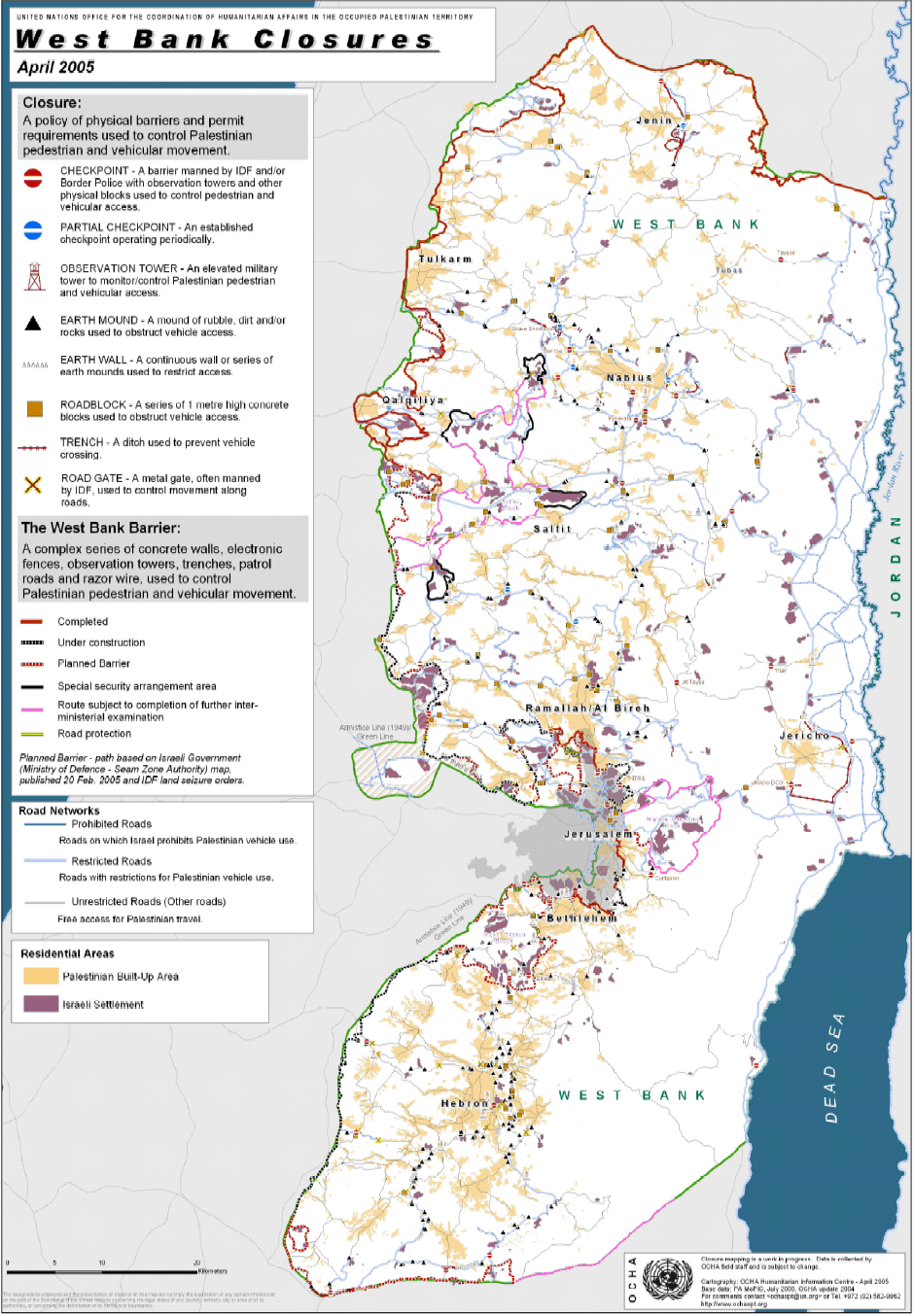
West Bank Closure and Access – April 20051
Introduction:
This report reviews the status of the closures as of 12 April 2005 and compares them with the situation in November 2004.
The West Bank closure system comprises over 600 physical barriers placed by the Israeli Defense Forces (IDF) on roads to control and restrict Palestinian vehicular traffic, which the Israeli Government states is designed to protect Israeli citizens from Palestinian attacks.
The closures are the primary cause of poverty and the humanitarian crisis in the West Bank and Gaza and have restricted Palestinian access to health and education services, employment, markets and social and religious networks. The types of barriers include full-time and partially manned checkpoints, roadblocks (consisting of rows of 1-metre concrete blocks), metal gates, earth mounds, earth walls (a long series of earth mounds) and trenches. OCHA field staff collects the exact location of each barrier with a Global Positioning System (GPS). The information is then integrated into a Geographic Information System (GIS) and used to map each checkpoint or obstacle.
Key changes:
- As of 12 April 2005, 605 closure barriers were recorded in the West Bank compared to 680 in November 2004. The 605 figure indicates a net decline of 75 closure barriers (in certain governorates the IDF installed additional closure barriers).

- The bulk of the 75 net decrease occurred in selected areas: 34 were removed from the Bethlehem Governorate, 16 barriers from the Hebron Governorate and 12 from the Jenin Governorate.
- Most of the closure barriers removed were earth mounds – 92 – which mostly benefited movement between individual Palestinian villages.
- Movement between governorates improved with the easing of two checkpoints: the Shave Shomeron checkpoint between Jenin, Nablus and Qalqiliya; and at the Ein ad Duyuk checkpoint, between Jericho and Ramallah, which was relocated following the handover of security of Jericho City to the Palestinian Authority.
- Movement in the northern West Bank has continued to improve.
- Four IDF manned checkpoints were removed: two in Nablus, one in Bethlehem and one in Hebron.
- An increase of flying checkpoints (random stop and searches) has been observed at locations where earth mounds were removed.
- UN movement into the closed areas between the Barrier and the Green Line has been restricted. Entry into Jerusalem has also become increasingly problematic with UN vehicles experiencing a significant increase in delays and denials.
- In areas where the changes in closures occurred, the removal of closure barriers is consistent with an observation that Palestinian vehicular traffic is being shifted away from routes used by Israeli settlers and from the Barrier (or its planned route).


I. Analysis by Governorate
Jenin and Tubas Governorates:

• The removal of 13 earth mounds and 6 trenches follows a trend of an easing of the closures in the Jenin Governorate since November 2003. Movement today within the governorate is relatively easy.
• No changes have occurred in the Tubas Governorate with Tayasir checkpoint (on the road to the Jordan Valley) remaining one of the
most remote and difficult checkpoints for Palestinians in the West Bank to cross.
• Flying checkpoints have been more frequent in both of these governorates.
Nablus Governorate:

• All the checkpoints surrounding Nablus City remain in place.
• In December 2004, the Shave Shomeron checkpoint ceased to be fully manned. (It is occasionally manned and has therefore changed status to a partial checkpoint). This change is significant as it opens up a major route for Palestinian movement between the governorates
of Jenin, Tulkarm and Qalqiliya as well as south towards Ramallah. Movement into Nablus from this location is still hampered by the checkpoints surrounding Nablus City.
• A series of earth mounds were removed from the villages of Tell, Sarra and ‘Iraq Burin, which had effectively closed these villages for the last three years. Access to Nablus – their main service center – is now possible. The west entrance to these villages as well as all roads
leading to Road 60, remains closed by earth mounds.
• An earth mound was re-established blocking the main entrance to Salem, Deir al Hatab and ‘Azmut villages. The earth mound had been
removed in December 2004 but with its reinstatement, vehicular movement is not possible.
• Movement through the checkpoints of Huwwara and Beit Iba has generally improved, with extended opening hours – both are now officially open until 11 pm for entry for Nablus residents and 6 pm for exit. Previously it was open from 8 am – 6 pm. Since February 2005, pedestrians entering Nablus are only checked on an ad hoc basis while those leaving continue to receive thorough individual checking.
• The vehicular lane at Huwwara checkpoint out of Nablus has been narrowed preventing ambulances and humanitarian traffic from moving to the head of the queue. The situation has been raised by several international organisations and the UN to the IDF, but no improvement has yet occurred.
• The checkpoints of Hamra and Ma’ale Efrayim remain among the most remote and difficult checkpoints for Palestinians to cross.
Tulkarm and Qalqiliya Governorates:

• Few changes were reported since November 2004.
• The completed Barrier constitutes the biggest closure obstacle for movement in and out of the “Closed Areas” (see “Closed Areas” section of this report). East of the Barrier (the “West Bank side”) movement is relatively unobstructed.
• The shift of security control over Tulkarm City and its countryside from the IDF to the Palestinian Authority on 3 March has been positive for Palestinian movement.
• There are fewer restrictions at Kafriat checkpoint, the main entrance to Tulkarm.
• Since the end of March, the Anabta Gate (Tulkarm) has been opened for vehicular traffic. Following the handover to the PA, the gate was
removed.
• The tunnel between Habla and Qalqiliya has remained open.
• There has been no enforcement of the prohibition for Palestinian citizens of Israel to enter both Tulkarm and Qalqiliya towns.
Salfit Governorate:

• Movement between the villages of Salfit and Nablus, where most Palestinian villagers depend on expanded services, continues to be hampered by closures and restrictions to travel on the main roads.
• Ambulances have been forced to rely on back-toback transfer of patients – transfer from one ambulance to another.
• Movement from the town of Salfit to Nablus and further south improved with the replacement of a road gate at Yasuf. The gate is open daily from 5 am to 7 pm.
• Salfit remains divided by Route 5, the highway running to Ariel settlement, which extends more than 20 kilometres eastward into the West Bank. Palestinian movement north – south across this route is restricted.
Ramallah Governorate:

• The main checkpoints in the Ramallah Governorate remain in place.
• An increase in the number of flying checkpoints has been observed where earth mounds have been removed, e.g., at the entrance of Deir Abu Mash’al, next to Ras Karkar, and at main roads.
• The main route at Surda has experienced particularly problematic flying checkpoints.
• Concrete roadblocks have replaced earth mounds to prevent access from the southwestern Palestinian villages onto Road 443.
• Umm Safa village’s two main entrances (onto Road 465) remain blocked and access for villagers continues to be problematic.
• A closure on the road leading to Ni’lin village has been removed, thereby improving access for the inhabitants of Ni’lin and Al Midya villages.
Jerusalem Governorate:

• Barrier construction around Jerusalem is ongoing along the projected route. Palestinian movement is becoming increasingly problematic due to Barrier construction and flying checkpoints in the Israeli Jerusalem Municipality boundary areas.
• There is also great concern among Palestinians regarding how access in and out of Jerusalem will be possible after the Barrier is completed.
• Movement for Palestinian communities outside of the Barrier route is likely to be shifted towards Ramallah and Bethlehem through a new system of underpasses and other crossing points.
• The removal of roadblocks near Jaba’ village has not significantly improved movement, since access for the inhabitants had been diverted to alternative roads.
Jericho Governorate:

• On 16 March, the IDF handed over security responsibility of the city back to the PA resulting in a significant and positive change for Palestinian movement between Jericho and the Ramallah Governorate.
• The ‘Ein Ad Duyuk checkpoint (renamed “Yitav”), has been relocated north near the Israeli settlement of Yitav enabling free access for Palestinians between Jericho and Ramallah.
• The At Taybe checkpoint between the Ramallah Governorate and Jericho remains in place, but with random checking only.
• The DCO checkpoint is still manned by the IDF. Restrictions on Palestinian holders of West Bank ID cards have been lifted, and the checkpoint is open for them 24 hours. The IDF is allowing Palestinian citizens of Israel entry but has prohibited the entry of Jewish Israelis.
Vehicles entering are randomly checked, while vehicles exiting are subject to more regular checks.
Bethlehem Governorate:

• The decrease of 34 closure barriers since November 2004, constitutes almost half of the total net decrease of barriers in the West Bank since November. The decrease was mostly in the removal of earth mounds.
• In the east, the Noqedim checkpoint has been removed as well as closures along roads 356 and 398 north to the “Container” checkpoint.
• There is a substantial increase of Palestinian movement on roads that have been restricted, especially Road 60 between Bethlehem and
Hebron governorates.
• It is expected that Palestinian movement on Road 60 (the main north-south road in the southern West Bank), will be reduced with the
construction of the Barrier. Most of the closure changes in the governorate, are consistent with the likely diversion of north-south Palestinian
vehicular movement away from the areas around planned Barrier route and Route 60, to the eastern side of Bethlehem along Route 356.
• Movement through the Efrata and Etzion checkpoints has been relaxed. The checkpoints are manned only intermittently and generally
movement is not impeded.
• Closures have also been lifted on the road connecting Al Jab’a to Surif, in the western side of the governorate, allowing unrestricted
movement for both private and public transport.
Hebron Governorate:

• There are now 16 less closures in Hebron Governorate than in November 2004. Taking into the account the total number of closures in this district, this does not represent a significant change in access and movement for Palestinian residents.
• Restrictions to and from the city of Hebron and fragmentation of the district remain. Although movement on roads is now possible on roads
formerly restricted for Palestinians, the entry/exit points into Palestinian urban areas from these routes remain closed. Palestinian movement is therefore limited to defined routes, mostly within “areas A” – areas transferred to Palestinian control under the Oslo Agreements.
• Despite the lifting and/or shifting of several closure barriers, the overall closure regime in Hebron-H2 (the Palestinian areas) imposed by the IDF to protect Israeli settlements in this area remains restrictive. These extended closures are severing Palestinian neighborhoods in the old city of Hebron from each other and the rest of the city.
• In the southeast, the security regime has not relaxed and access for Palestinians and vehicles remains difficult – more earth mounds and trenches have been established on both sides of road 317.
II. Movement and access to and from the Closed Areas west of the Barrier
• Movement into and out of the closed areas between the Green Line and the Barrier continues to be restricted for Palestinian farmers. These farmers are required to pass through gates in the Barrier to reach their land. The gates have limited opening hours and remain open only for those farmers who are able to fulfill the requirements to obtain special permits (known as “green permits”) from the Israeli authorities.
• Most of the 5,000 Palestinians who live in the closed areas must cross the Barrier into the West Bank to reach humanitarian and other basic services. Their movement is also restricted through limited gate opening times and green permit requirements.
• The IDF installed a new electronic system at the gate for Azzum Atma village. This system has caused major delays through the Barrier for residents, teachers and in particular school children. The IDF screens every person and belongings before allowing persons to pass through the gate.
• Movement for the five Palestinian villages located inside the Alfe Menashe settlement enclave remains problematic as need to pass through a Barrier gate whose opening times are limited to three times a day. School children from these villages continue to be transported by IDF-rented buses through the Barrier.
• Movement of Palestinian staff working with humanitarian organisations in the closed areas is also restricted. For staff to enter, they must coordinate with the IDF prior to entry or obtain a green permit.
• UN humanitarian agencies are not applying for separate green permits for their Palestinian staff to enter the closed areas on the grounds that these areas are part of the West Bank. As a result, their access has been frequently denied.
• Jerusalem – Access into Jerusalem has been frequently denied to UN staff in the first three months of 2005. The IDF, at some checkpoints, particularly Hizma, have refused to recognize UN identity cards that until now have been accepted.
________________
1 OCHA oPt has been monitoring and mapping the impact of the closures and the Barrier on humanitarian access and movement in the West Bank and Gaza Strip since June 2003. Closure mapping is a working progress. Closure data is collected by OCHA field staff, and is subject to change.

Document Type: Arabic text, Map, Report
Document Sources: Office for the Coordination of Humanitarian Affairs (OCHA)
Subject: Closures/Curfews/Blockades, Fence, Palestine question, Separation barrier, Situation in the OPT including Jerusalem, Wall
Publication Date: 12/04/2005