
The Humanitarian Impact of the West Bank Barrier on Palestinian Communities
March 2005
Update No. 5
A report to the Humanitarian Emergency Policy Group (HEPG),
compiled by the United Nations Office for Coordination of Humanitarian Affairs (OCHA) and
the United Nations Relief and Works Agency for Palestine Refugees (UNRWA) in the occupied Palestinian territory.1

|
This report is divided into four parts:
|
Introduction
Concerned that Palestinian livelihoods and access to essential services would be harmed by the construction of the West Bank Barrier, the international donor community – through the Humanitarian Emergency Policy Group (HEPG) – requested regular updates on the humanitarian impact of the Barrier. The HEPG comprises the European Commission and the EU President, the World Bank, USAID, Norway and UNSCO. This is the fifth such update and it is compiled by the UN Office for the Coordination of Humanitarian Affairs (OCHA) and the United Nations Relief and Works Agency (UNRWA) in the occupied Palestinian territory.
This report cannot do justice to all the humanitarian issues arising from the Barrier. It aims to provide an accurate account of its route and a general overview of its impact. The case studies seek to enhance understanding of the Barrier's impact on daily lives. Nevertheless, it is difficult to overstate the humanitarian impact of the Barrier. The route inside the West Bank severs communities, people's access to services, livelihoods and religious and cultural amenities. In addition, plans for the Barrier's exact route and crossing points through it are often not fully revealed until days before construction commences. This has led to considerable anxiety amongst Palestinians about how their future lives will be impacted.
Overview and Key Developments of the Latest Barrier Route
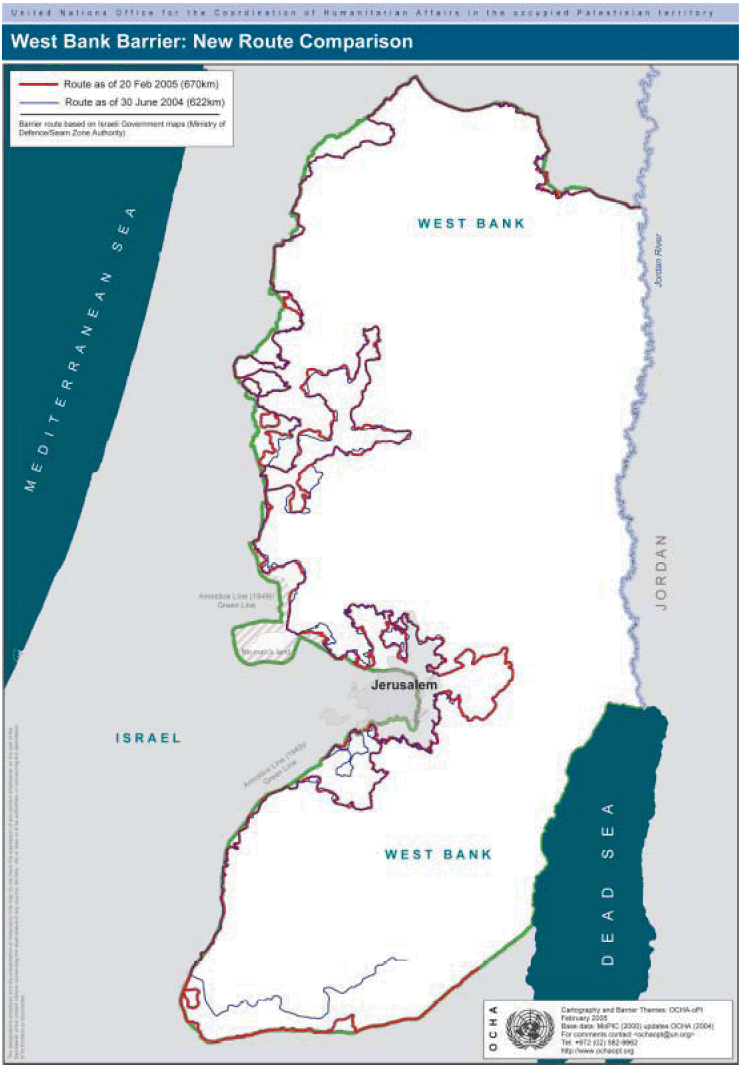
1. On 20 February 2005, the Israeli cabinet approved a revised route of the West Bank Barrier and published a map on the Ministry of Defense's website, (www.seamzone.mod.gov.il). The previous map was released on 30 June 2004.
In June 2002, the Government of Israel began construction of the Barrier following several suicide bombings and attacks by Palestinian militants on Israeli citizens. It maintains that the Barrier is a temporary structure to physically separate the West Bank from Israel to prevent such attacks on Israeli citizens.
2. An analysis of the map of the new route includes six categories: completed, under construction, planned, special security area, route subject to the completion of further inter-ministerial examination, and road protection.
3. Once completed, the total length of the new Barrier route will be 670 km long compared to 622 km of the previous route. This includes the sections around the Ma'ale Adumim settlement and Ari'el/Emmanuel settlement 'fingers' which are marked on the Ministry's map as, "subject to completion of further inter-ministerial examination". Together these two areas total 108 km or 16% of the route.
4. As of February 2005, approximately 209 km of the Barrier has been completed. This section consists of a combination of ditches, trenches, roads, razor wire, electronic fences and concrete walls. The Head of the Knesset Economics Committee estimated that the Barrier will cost $3.4 billion.
Analysis of Humanitarian Impact
Land affected
5. If the Ma'ale Adumim and Ari'el/ Emmanuel sections, marked as "subject to the completion of further inter-ministerial examination" are included, then approximately 57,056 hectares2 or about 10.1% of West Bank and East Jerusalem land will lie between the Barrier and the Green Line.
6. The previous Barrier route incorporated 69,744 hectares or 12.7% of the West Bank and East Jerusalem. The 2.5% decrease in the land area located between the Green Line and the Barrier, is largely due to the shift of the Barrier back to the Green Line in the South Hebron area.
7. A larger decrease in affected land would occur, if the sections marked subject to completion of further inter-ministerial examination, Ma'ale Adumim and Ari'el/Emmanuel, were excluded. Then only 6.8% of West Bank and East Jerusalem land would be incorporated by the Barrier.
Palestinian population affected
8. The land between the Barrier and the Green Line constitutes some of the most fertile in the West Bank. It is currently the home for 49,400 West Bank Palestinians living in 38 villages and towns.3
9. The previous Barrier route had approximately 93,200 West Bank Palestinians living between the Green Line and Barrier. The reduction in population is due to an easing of the closures in Qalqiliya (population 45,800). While the city remains encircled by the Barrier, the checkpoint at the entrance of Qalqiliya is not manned.
10. Approximately 230,000 Palestinians hold East Jerusalem residency permits. About one-quarter of these people are located on the West Bank side of the Barrier and will need to cross the Barrier to access to services which they are entitled inside Jerusalem.
11. The Barrier will also affect those people living east of it who may need to cross it to get to their farms, jobs and services. More than 500,000 Palestinians, for example, live within a one kilometre strip of the Barrier.
Affect of the Planned Ma'ale Adumim Section
12. Extending 14 km east across the most narrow section of the West Bank, the planned Ma'ale Adumim section will impede movement between the northern and southern areas of the West Bank, blocking the current roads used by Palestinians to travel between these areas.
13. For Palestinians residing in and around East Jerusalem, the addition of the Ma'ale Adumim section will increase existing movement restrictions created by the constructed parts of the Barrier.
Barrier length
14. Stretching a total of 670 kilometres, the new Barrier route will run from the northern Jordan River in Eastern Tubas to the southern- most tip of the West Bank in the Hebron Governorate. Because of its meandering path into the West Bank, the Barrier's length is approximately twice the length of the 1949 West Bank Armistice Line adjacent to Israel, known as the Green Line – 315 km. The length of the Barrier will be 129 km less if the sections labeled "subject to completion of further inter-ministerial examination" are removed.

Departure from the Green Line
15. 20% of the Barrier's length runs along the Green Line. More of the Barrier is now planned to be on the Green Line primarily as a result of the shift of the southern route in Hebron towards the Green Line.
16. The Barrier's planned path extends into West Bank land in many places. In the planned Ari'el/Emmanuel finger, the Barrier extends 22 km or 42% across the width of the West Bank. In the planned Ma'ale Adumim section, the Barrier route extends into the West Bank 14 km or 45% of its width.
New Buffer Zone
17. In areas where the Barrier has been constructed, the IDF issued military orders in September 2004, creating a strip averaging 150-200 metres on the West Bank sides of the Barrier where new construction is prohibited.
Other Changes to the New Route:
• Khirbet Jbara – Tulkarm Governorate: The cabinet approved moving a 6 km section of the Barrier in this area closer to the Green Line. As a result, the Palestinian population in this area will no longer be located in a “closed area”, but rather on the West Bank side of the Barrier.
• The new route adds 20 km along the Green Line in South Hebron and is marked on the map as “subject to completion of further inter-ministerial examination.”
• Road Protection Structures: The new route contains two sections marked as “road protection structures”. They constitute an additional 10 km of barrier and close off the Gush Etzion (West Bethlehem) and Bir Nabala (North Jerusalem) areas.
• Special Security Areas: These areas are marked in the Ari'el/ Emmanuel settlement fingers where some requisition orders have been issued and/or construction has begun along the planned route.
Access to jobs and services
18. Israel has taken a number of steps to facilitate Palestinian movement. It has constructed Barrier gates and built tunnels under roads restricted for Palestinian use, which connect Palestinian areas affected by the Barrier. However, these steps have not enabled Palestinians affected by the Barrier to fully resume their normal daily routines and movement.
19. Palestinians who live in "closed areas" are required to pass through gates in the Barrier to reach markets, schools, hospitals and maintain family connections in the remaining areas of the West Bank. Although Israel introduced some changes to the operation of the gates, access for Palestinians in these areas is restricted.
20. In February 2005, UN staff observed 63 gates in the constructed Barrier. Of these, 25 are accessible to Palestinians with the correct permit – two more since September 2004. The Israeli Government has not released information on which access gates will be opened through the planned routes of the Barrier. This is particularly significant in the Jerusalem area, where tens of thousands of Palestinians remain uncertain as to how they will be affected.
Israeli settler population between the Green Line and the Barrier
21. With the addition of the Ma’ale Adumim section, 56 West Bank Israeli settlements (excluding East Jerusalem settlements) will lie between the Barrier and the Green Line. This comprises 76% of the West Bank settler population or 170,123 Israeli settlers. In addition, there are over 170,000 Israeli settlers in East Jerusalem settlements who will be between the Barrier and the Green Line.4
Palestinians require permits to continue residing in “closed areas”
22. Palestinians residing in “closed areas” between the Barrier and the Green Line face an uncertain future in terms of their personal and land status. On 7 October 2003, the Israeli Defence Forces issued a number of military orders declaring “closed”, land areas located between the Barrier and the Green Line in the Jenin, Qalqiliya and Tulkarm districts. Those orders require approximately 5,000 Palestinian residents of the closed areas” to apply for ‘green’ permits to remain living in their homes. The permits are valid for up to a year for residents and only for one gate. Use of other gates is also militarily regulated and allowed only in emergency cases.
23. The Barrier will further restrict farmers living outside closed areas from reaching their land. Medical staff, business people and international humanitarian
organizations also have to apply for green permits. According to the military orders, Israeli citizens, Israeli permanent residents and those eligible to immigrate to Israel in accordance with the Law of Return, are exempted from these requirements.
24. If the military orders that restrict entry into the “closed areas” between the Green Line and the Barrier are applied to the new parts of the Barrier, then many more thousands of Palestinians are likely to face similar difficulties.
Humanitarian consequences
25. Where the Barrier has been constructed, Palestinians face economic hardship from being restricted from or not being able to reach their land to harvest crops, graze animals or earn a living. Residents have also been cut off from schools, universities and specialized medical care by the constructed Barrier. (See specialized sections of the report.)
26. The damage caused by the destruction of land and property for the Barrier’s construction will take many years to recover and hinder Palestinian development should a political situation allow this.
27. The Barrier also fragments communities and isolates residents from social support networks. Even where the Barrier route does not encircle an area as an enclave, its presence may still impact a community. For example, the Barrier route surrounds on three sides approximately 43,900 Palestinians residing in communities between At-Tira and Beit Sira northwest of Jerusalem.
Legal and international developments
28. The 20 February 2005 route is the first revision of the Barrier’s route since the advisory opinion of the International Court of Justice (ICJ) was issued on 9 July 2004. In that opinion, the ICJ stated:
29. On 20 July 2004, the General Assembly, in resolution ES-10/15, called on Israel to comply with the legal obligations identified in the ICJ advisory opinion.
30. As yet no publicly available studies have been conducted by the Israeli Government to measure the Barrier’s impact on Palestinian lives. However, the Israeli High Court of Justice ruled on 30 June 2004 in the “Beit Surik” case (H.C. 2056/04), that the “rights, needs, and interests of the local population” must be considered in designing the route. The Beit Surik decision led to an Israeli re-examination of the Barrier route.
31. Palestinian landowners continue to petition the Israeli High Court of Justice against the current planned and/or constructed Barrier route. The petitioners claim among other things, that the amended route does not meet criteria set out by the Israeli High Court or the ruling of the International Court of Justice and causes undue harm to Palestinians lives and livelihoods.
32. In a letter to the president of the United Nations General Assembly on 11 January 2005, UN Secretary-General Kofi Annan discussed the establishment of a registry of damages caused by Israel’s construction of the Barrier. In the letter, Annan set out a framework for the registry and the next steps for its
establishment.
33. On 23 February 2005, the Israeli state attorney filed its position on the implications of the International Court of Justice (ICJ) on the Barrier for the Israeli High Court of Justice. The response was filed six months after the Israeli court had first requested this. The State Authority argued that the opinion of the Barrier was irrelevant since it was based on partial and outdated information. The Palestinian petitioners intend to submit a response to the State Attorney’s position.
34. From the start of construction until January 2005, 65 petitions were submitted to the Israeli High Court of Justice by Palestinian landowners and concerned parties regarding the Barrier, 51 dealing with the route. Of the 51 petitions, 15 were withdrawn by consent of both sides (in many cases following a change in the route), 10 were rejected, and one petition was accepted. The remaining 26 are still pending in the court.5
Background

Israel has stated that the Barrier was conceived by the Israeli Defense Establishment in order to reduce the number of terrorist attacks. It maintains that “the path of the Security Fence was planned in accordance with security and humanitarian concerns and… is intended to counter terrorism of the most brutal kind, not to dictate a border that is and remains the subject of permanent negotiations. It is our hope that by building this fence its very function will become irrelevant and that one day it will be dismantled…It should be noted that in addition to security considerations, Israel has made every attempt to plan the route so as to avoid any undue hardship to the local population. For example, changes were made after Israeli authorities conducted negotiations with landowners in which their particular needs were taken into account.”7
The Palestinian Liberation Organization stated that the Barrier’s construction within the oPt violates international humanitarian law because it is not justified by military necessity and violates the principle of proportionality. “The harm caused to the Palestinian civilians include: extensive destruction of Palestinians homes and other property…infringements on the freedom of movement…the rights to education, work, and an adequate standard of living and health care…violations of the prohibition against arbitrary interference of home….” The PLO maintain that the “construction of the Barrier is an attempt to annex the territory… and the de facto annexation of land interferes with the territorial sovereignty and consequently with the right of the Palestinians to self-determination.”8
The UN Secretary -General has reported to the General Assembly that :
North West Bank Barrier
Tubas | Jenin | Tulkarm | Qalqiliya | Salfit


| Tubas
1. Construction of the Barrier is complete on or near the Green Line along the north side of Tubas Governorate. Barrier construction is fence-like in this area, and stretches from the Jordan River west to Al Mutilla in the Jenin Governorate.
In December, farmers in Bardala received verbal notification from the IDF, warning them not to cultivate their land or grow plants taller than 50 centimeters along the Barrier from a distance of 500 metres from the Bisan checkpoint down to the Jordan River.
A terminal-like structure is under construction at Bisan checkpoint, at the intersection of the completed Barrier and Jordan Valley Road 90.
| Jenin
2. The 20 February 2005 new Barrier projections map officially cancelled the planned Barrier section in the Jordan Valley – from Al Mutilla south to the Tayasir/Al ‘Aqaba villages.
3. The Barrier is complete from Al Mutilla in Jenin to Dhaher al ‘Abed, north of Qaffin in Tulkarm Governorate. The path of the Barrier runs near the Green Line from Jalbun to ‘Anin. South of ‘Anin, the Barrier extends eastward running along hilly terrain around Barta’a ash Sharqiya area villages – creating a “closed area”. This “closed area” includes three Israeli settlements and six Palestinian communities with a combined Palestinian population of 5,830.10
Palestinians working for international organisations have experienced delays entering and have been denied access to the Barta’a ash Sharqiya villages. The IDF has stated that the area is a “closed area”, and that it has the right to determine who can enter. Palestinians working for international organisations and NGOs are therefore subjected to the green permit system introduced by the IDF.11
Nearly all Palestinian residents of Barta’a ash Sharqiya have received green permits from the IDF allowing them to continue to reside in this area and to cross specific Barrier gates in order to enter and exit.
The population in this area has remained constant according to the village council of Barta’a ash Sharqiya. This may be because an estimated 40% of residents hold Israeli ID cards, due to their close proximity to the Green Line.


Case study: Jenin
Barta’a ash Sharqiya “closed area” – a family
isolated by the Barrier
‘Aziz Saleh Zeid (83), known as Sheikh ‘Aziz, and his family live in a house located between the Barrier and the fence surrounding Shaked settlement. The house is a part of Tura ash Sharqiya village (pop. 135), located in the Barta’s ash Sharqiya “closed area”, and is the only house that has been separated by the Barrier, on the ‘Israeli’ side of the Barrier.
There are eight adults and four children in the Zeid extended family. The members of the family residing on the ‘Israeli’ side of the Barrier have obtained the permits necessary to reside in the “closed area”. However, Sheikh ‘Aziz’s two sons who live in Tura ash Sharqiya – on the ’West Bank’ side of the Barrier – have not been able obtain permits to cross the Barrier and therefore have not been able see their father. Sheikh ‘Aziz is not physically fit to leave the house and has not done so since the Barrier was constructed.
The family has a special permit to enter the Umm ar Rihan gate, which has opening hours from 7am to 8am and from 1:30pm to 2:30pm. To reach the gate the family must walk through an opening in some barbed wire, which runs along the length of the Barrier and then continue approximately one kilometre on a restricted, settler road.
Accessing service providers located in Jenin or Ya’bad, need special coordination with the IDF to enter the area. Often permission is not granted. However, Israeli officials have facilitated the need for emergency medical treatment at times. In January, when Sheikh ‘Aziz’s two-year-old grandson was injured the family called the IDF Liaison Office, which decided, in accordance with the wishes of the boy’s family, to take the boy to Israel for treatment. The family is not, under normal circumstances permitted to travel to Israel.

Case study: Qalqiliya
Jayyous – Access to Agricultural Land
Jayyous is a farming community in the Qalqiliya Governorate. Jayyous village is located east of the Barrier, but approximately 70% of the village’s agriculture and all their irrigated land are located west of the Barrier. (See inset map on the North West Bank Barrier map). Access to this land in conjunction with further land leveling and tree uprooting, are threatening the community’s ability to support itself. The Jayyous area comprises one of the best agricultural lands in the West Bank. It is also located in the biggest olive and vegetable producing region.
Jayyous has six groundwater wells, all located on the opposite side of the Barrier. There are approximately 9,307 dunums (931 hectares) of fertile land; 2,000 guava trees – each with an annual yield of 100 kilograms of fruit – and as many as 12,000 olive trees isolated from the Jayyous community.12
On 9 December 2004, bulldozers uprooted 117 olive trees on Jayyous land, west of the Barrier, before the work was halted by the IDF. Ten days later the work resumed and some 300 to 350 olive trees were uprooted in total. The uprooting took place adjacent to the Israeli Zfim settlement.
An Israeli citizen and a Palestinian citizen from Jayyous both claim ownership of the land where the uprooting took place. This dispute remains unresolved.
Dirt roads leading from Jayyous to the village fields have been cut off by the Barrier. Many farmers cannot reach their land with tractors due to difficult
terrain and the lack of connecting roads. As a result, farmers often have to carry their produce more than 3 kilometres. Tractors and carts are permitted to pass through the Barrier at the discretion of the soldiers manning the gates.
Some Palestinians in this area lack green permits, which are required to cross the Barrier in order to access agricultural land. There are two agricultural gates for the farmers in the Jayyous area to access lands west of the Barrier.
* The Jayyous northern gate was open to more than 500 farmers holding green permits. Of these, about 120 cross the gate on a daily basis. These farmers cultivate olive trees, citrus trees and attend greenhouses on the west side the Barrier. Jayyous’ northern gate has the longest opening hours of all the agricultural Barrier gates: official opening hours are 5:45am to 7:15am, 12:30pm to 1:30pm, and 3:45 to 4:45.
* The Jayyous southern gate is open for one family (with six children who attend classes in Jayyous) whose house is behind the Barrier. A few shepherds also cross to graze some 300 livestock. Official opening hours are 7:30am to 7:45am, 1:45pm to 2pm, and 5pm to 5:15pm.
| Tulkarm
4. The constructed Barrier from Qaffin to Zeita was dismantled in February 2004. A new concrete Barrier was constructed closer to the Green Line. The new Barrier runs through Nazlat ‘Isa village, separating eight Nazlat ‘Isa homes (69 people) from the main part of the town, located east of the Barrier.
5. On 2 January 2005, bulldozers began levelling land between Tulkarm town and Kafriat checkpoint.13 The land levelling is in preparation for the construction of a tunnel passing under Road 57. With Palestinians increasingly unable to travel on Road 57 due to Israeli restriction, the tunnel will enable Palestinians to pass under the road to reach Tulkarm and the villages further south.
On 2 January 2005, the IDF issued an amended land requisition order to move the Barrier closer to the Green Line in the Khirbet Jbarah area,14 (see inset map, North West Bank Barrier). The new route will place Khirbet Jbarah east of the Barrier or on the West Bank side, together with approximately 3,160 dunums (316 hectares) of land. However much of the village farm land will remain west of the Barrier. The nearby villages of Ar Ras and Far’un also have farmland in this area from which they have been separated since 2003.
Relocating the Barrier will give Khirbet Jbarah residents and two refugee families from Ar Ras, whose homes are located on the west side of the Barrier, easier access to main service providers in Tulkarm. This includes the school children who are being transported to and from school by the IDF in rented buses. Currently, all residents of Khirbet Jbarah and visitors from outside the area are required by the IDF to have a green permit to cross the Barrier and access the village.
Despite the improvement in the humanitarian conditions and access for Khirbet Jbarah, the new route of the Barrier does not follow the Green Line. Local Palestinian residents, with the assistance of the Association for Civil Rights in Israel (ACRI) and the Jerusalem Centre for Human Rights, are currently appealing the route to the Israeli High Court of Justice.

| Qalqiliya
6. The completed Barrier runs south from Falamya, encircling Qalqiliya town, to Masha in Salfit District. This Barrier section includes both concrete and fence construction in the Qalqiliya area. On the west side of Qalqiliya town, a concrete section runs more than 3 kilometres along the Green Line.
7. On 31 August, the IDF completed the construction of a tunnel under Israeli-controlled Road 55. The tunnel aims to facilitate travel between Qalqiliya and Habla and the Palestinian villages further south, which have been blocked by the Barrier and closures. Even with the tunnel, farmers from Qalqiliya and Habla will need to continue to use the existing Barrier gates to access their agricultural lands. The tunnel is surrounded by IDF controlled gates on each side, which have closed the tunnel on occasions.
Movement in and out of the five Palestinian villages (pop. 900) enclosed in the Alfe Menashe enclave has not improved. On 31 August 2004, the Association for Civil Rights in Israel submitted a petition to the Israeli High Court of Justice to dismantle this section of the Barrier.
The petitioners stated that the Barrier denies Palestinians access to Palestinian agricultural land and towns, where educational and health services are provided. The issue has not been resolved and the case is still ongoing.
The IDF has made efforts in this area to facilitate movement for Palestinian school children by providing a school bus service to carry students to and from schools through the Barrier.
8. The 20 February 2005 new Barrier route has reintroduced the enclave circling ‘Azzun Atma village. The residents of this 4,008 dunum (401 hectare) enclave (pop. 1,711) have not been required to obtain residential green permits to enable them to remain in their homes. However, those visiting the area through the Barrier gates require visitor permits.
| Salfit
9. The Barrier is complete north of Masha. This section of the Barrier includes a 50-metre section of 8 to 9 metre-high concrete wall slabs. The slabs have been placed in front of a single home, leaving it isolated west of the Barrier.
10. The 20 February 2005 new Barrier projections map reroutes the Barrier in Salfit District near the villages of Az Zawiya, Rafat and Deir Ballut. The planned Barrier runs on the west side of Az Zawiya, Rafat and Deir Ballut villages – then southward into Ramallah Governorate.
If the Ari’el/Emmanuel “fingers” continue as planned on the east of these villages, the Barrier will encircle Deir Ballut, Rafat and Az Zawiya on three sides. Currently, the three villages have some access to Ramallah and Nablus, the primary service providers for this area, however access will restricted if the Barrier is completed.
Despite revision, some 40 to 50 Bedouins (about eight families) who live on these lands will remain isolated behind the Barrier. According to the village councils of Az Zawiya and Deir Ballut, these Bedouin families have been informed on several occasions by the IDF that they must relocate.
On 15 December 2004, the Israeli High Court of Justice ruled in favour of a petition from area Palestinians against the original planned route of the Barrier.15 One day after the ruling, the IDF issued two new requisition orders with maps covering 78.1 dunums (7.8 hectares) of land near Deir Ballut and 389 dunums (38.9 hectares) near Az Zawiya. Immediately after, the IDF started to level the land according to the new requisition orders. The levelling is ongoing; however, no trees have been uprooted to date.
11. The planned Ari’el/Emmanuel “fingers” will create a large settlement enclave with 14 settlements, (pop. 38,534 settlers),16 and 4 Palestinian villages, (pop. 101).
The February 2005 Barrier map changes the route in some areas of the Ari’el/Emmanuel “fingers”, reducing the overall amount of West Bank land incorporated by these fingers by 1% from the previous route. Parts of the route are subject to completion of further Inter-Ministerial examination, other sections are marked as “special security arrangement” areas. If this entire section is included in the Barrier, as planned it will enclose 123 km2 of West Bank land. The Ari’el “finger” extends 22 kilometres into the West Bank or 42% of the width of the West Bank. The Barrier around Ari’el and Emmanuel, once constructed, will have a significant effect on territorial contiguity and north-south access within the West Bank.
Several sections of the special security arrangement areas have been issued with land requisitions orders and are under active preparation. The IDF resumed working on a four kilometre segment between Salfit town and Ari’el settlement, covering 267 dunums (27 hectares). This section was requisitioned on 28 May 2004. Construction was suspended by the Israeli High Court of Justice after a petition was made by Salfit residents. A second section of land, east of Emmanuel was requisitioned on 1 February 2005, however no construction has begun.


Case study:
Olive Harvest – 2004
Forty-five percent of Palestinian agricultural land is planted with olive trees and many local Palestinian communities in the West Bank depend on the olive harvest to survive. The 2004 harvest (August to November) was a particularly important, as it was the high yield year, of the two year olive harvest cycle. Israel pledged to assist Palestinian farmers during the harvest in agreement with Palestinian DCL councils. The arrangements included expanded opening hours of Barrier gates, additional Israeli security personnel in the field to ensure proper coordination with farmers, and security provisions for Palestinian farmers from Israeli settler harassment.
Nine seasonal gates were reported open in the last Update – based on IDF official announcements. Of these nine, four operated during the 2004 harvest. However, another eight unannounced gates were opened by the IDF to accommodate farmer access to their fields in other areas.
However, access is necessary throughout the year to ensure healthy trees and a successful harvest. It has been increasingly difficult for farmers to care for their land, during the year because of access restrictions, changes in gate operations and the rejection of valid permits.
* In the Qalqiliya Governorate, which has the largest amount of agricultural land isolated behind the Barrier, rejection of permits on security grounds or failure to prove ownership restricts access to agricultural land. For example in Jayyous, the biggest olive-producing region in Qalqiliya, it was estimated that some 170 farmers out of 700 who applied for access permits were rejected.
During the harvest, travel in the area also was problematic due to lack of adequate roads and restrictions to travel on Israeli roads. Travel length also increased. In Ad Dab’a, for example, farmers had to travel 8 to 10 kilometres extra, through hilly terrain inaccessible to vehicles. In addition, farmers faced harassment from Quedumin settlement, which discouraged their harvesting.
* In the Tulkarm Governorate, which has the smallest amount of land isolated behind the Barrier, fewer incidents were reported. However, there were problems with applications for green permits.
* In the Salfit District, due to the high number of Israeli settlements in the area, farmers were highly vulnerable to harassment and access to their olive groves was restricted. Arrangements were made between Palestinian and Israeli officials that allowed for farmers, in accordance to a schedule, to pick their olives near the settlements. However, the schedule was only applicable to an agreed zone, which left other areas inaccessible.
* In the Bethlehem Governorate, two Barrier gates were announced open for the harvest, however, no gates were open during harvest time.
Central West Bank Barrier
Ramallah | Jerusalem | North Bethlehem


| Ramallah
1. The 20 February 2005 new Barrier route altered the map in northwest Ramallah Governorate. The section from Rantis east to Deir Ghassana, along the southwest section of the Ari’el “finger” has changed status from the previous route. This area is now a combination of “route subject to completion of further Inter-Ministerial examination” and special security arrangement areas. The special security arrangement area surrounds Ofarim and Beit Arye settlements on three sides – opening at the northern Ari’el “finger” extension. No land requisition orders have been issued in this area.
2. Fence-like Barrier construction between Rantis and Budrus is ongoing. The northern and southern sections are nearly complete with asphalted patrol roads, concrete foundations and electricity installed. In the middle section, the Barrier runs about 500 metres east of the Green Line where trees belonging to Shuqba village were uprooted last year. Land levelling was suspended after Shuqba villagers filed a petition with the Israeli High Court of Justice.
3. The Ofarim-Nili bypass road, running north-south some six kilometres east of the Green Line, is nearly complete. Villagers located between the Barrier and the bypass road fear that the road will act as a physical barrier isolating five villages: Al Midya, Ni’lin, Budrus, Qibya and Shuqba (over 16,000 Palestinians), restricting access to services in Ramallah city, particularly specialised health care. General access for Shabtin village (pop. 850 Palestinians)
may also be affected.
4. The new Barrier route north and east of Al Midya has been rerouted and land levelling started mid-January 2005.
Construction was suspended in the Ni’lin area after petitions were submitted to the Israeli High Court from Ni’lin village and from Israeli settlers. Concurrent to Barrier construction, settlement housing expansion is underway nearby Modi’in Ilit and Mattiyahu settlements, near the planned Barrier route. Over the last year the Modi’in Illit settlement population grew by 14%, bringing the population to 27,301.17
The route of the Barrier was also move further west, (an average of 400 metres), from Deir Qaddis to west of Bil’in. New land levelling that had began 20 February, west of Bil’in towards Saffa village on both village lands, was suspended on 23 February 2005.
5. The new Barrier route south of Road 443, was redrawn after several rulings by the Israeli High Court of Justice. The new Barrier route is closer to the Green Line in some areas than the previous route. Specifically, it is closer in two stretches from Beit Nuba to Kharayib Umm al Lahim and Al Qubeiba – around Beit Surik to Biddu. Two additional smaller sections were also rerouted – west of Saffa and east of Beit Duqqu. The new planned route is closer to the Green Line, but lies mostly on West Bank lands and will continue to separate some Palestinian farmers from their agricultural lands.
The route will also place Beit Iksa and An Nabi Samwil on the ‘Jerusalem side’ of the Barrier, separating them from neighbouring communities. A gate is planned at Biddu, to operate 24 hours a day and facilitate their access to villages located south of Road 443.
Access for communities located south of Road 443 has been blocked by earth mounds and roadblocks since 2000/2001. Road 443 is a four-lane highway on which Palestinians are not allowed to travel unless they have the required permit. Thirteen villages (pop. 43,946) have one vehicle access road from this area to the north – under Road 443 near Kharbatha al Misbah. Special permit holders can also exit this area through the Ramot Allon checkpoint, near Beit Iksa to the east. The IDF has indicated a new passage and tunnel will connect this area to the Bir Nabala enclave.
Barrier construction had begun in this area in late February 2004. On 30 June 2004, the Israeli High Court of Justice ruled that a 30 kilometre stretch from Beit Sira to Beit Ijza of planned Barrier northwest of Jerusalem should be revised. The court noted that this stretch of the Barrier, contested on behalf of the Beit Surik village council, would cause injury to Palestinian lives and land, and that the harm to the residents way of life was disproportionate to the security benefit of the route. Following the Israeli High Court of Justice decision in the Beit Surik case, the IDF presented an alternative route on the 27th of January 2005. The new plans were contested, this time by nine different local councils that appealed to the Israeli High Court on 13 January. The Court ordered the construction to halt until the ruling with was made on 8 February 2005. The Court stated that IDF was allowed to continue construction according to the new proposed route from Bet Liqya to Beit Surik.
Barrier construction is nearly complete between Beit Sira and Beit Nuba, however, the electronic fence has not yet been installed.
Barrier construction resumed south of Beit Liqya on 22 December 2004, but was halted after villagers submitted an appeal to the Israeli High Court. Construction in this area remains suspended. In the meantime, six land requisition orders for different sections of the stretch from Beit Liqya to Biddu were issued. Land levelling on Biddu and Kharayib Umm al Lahim lands began on 11 January. In Kharayib Umm al Lahim approximately 600 metres of land have been cleared. The leveling runs very close to Palestinian houses – as close as 50 meters in places. Fifty olive trees have been marked for uprooting. On 13 January, construction was halted by an Israeli High Court order.
Barrier construction has begun in Qatanna extending to Al Qubeiba, north of Har Adar settlement.
The IDF levelled 3, 300 metre stretches of Bet Surik land, located on the southern, eastern and western sides of the village.
Land levelling continues from Beit Duqqu along hilly terrain to north At Tira and Road 443 – approximately 4 kilometres.
Land levelling continues between Beit ‘Ur al Fauqa and Beituniya.
6. Barrier construction on Beituniya town land is nearly complete, although the electronic fence has not been erected.
A fence-like Barrier construction from Beituniya checkpoint extending to Qalandiya checkpoint was completed in spring 2003. Recently, the fence-like structure was replaced by concrete slabs running from the Jerusalem Airport (non-operational) to Qalandiya checkpoint.
| Jerusalem
7. The 20 February 2005 Barrier route has extended the boundaries of the Bir Nabala enclave on three sides and included a new Barrier construction type – road protection – which extends across the north. The road protection is expected to be constructed much like the Barriers on Road 443 and will physically block Bir Nabala communities from accessing Ramallah, to the north by a direct road.
Instead, two tunnel routes will connect this enclave to other Palestinian communities. One tunnel has been completed and connects the Bir Nabala community to the north, at Qalandiya village. There are indications that part of the completed Barrier, north of Qalandiya village, may be removed. A second tunnel, under Road 436 is planned to connect the Bir Nabala enclave to the west, from Al Jib to Biddu and the communities south of Road 443.
The path of the Barrier encircles four villages: Bir Nabala, Al Jib, Al Judeira and Beit Hanina al Balad (total pop. 14,647) and isolates much of the villages’ agricultural land. Al Jib, for example, will be separated from more than 3,000 dunums (300 hectares) of agricultural land. The Barrier will make it difficult to access service centres, such as Ar Ram, Dahiyat al Bareed and Jerusalem currently used by these communities.
Land requisition orders were issued on 29 January 2005 to build the Bir Nabala enclave. The orders requisition 1,466 dunums (147 hectares) of land.
8. The Qalandiya checkpoint area is under construction. According to the Israeli DCL,18 plans include expansion to a terminal-like checkpoint located 200 metres southwest of the present site. It is unclear how the new terminal-like checkpoint will cope with the large number of daily commuters traveling to and from Jerusalem.19
9. In June 2004, preparation work for Barrier construction between Al Ram and Qalandiya checkpoints started. The Ar Ram local council petitioned
the Israeli High Court of Justice against the planned Barrier and a court hearing took place on 28 June 2004 in which the IDF was advised to look into alternative plans for the part of the Barrier surrounding Ar Ram and Dahiyat al Bareed. Construction work stopped on the main road until a suicide attack on Border Police occurred close to Qalandiya checkpoint on 11 August, after which construction again resumed.
The planned route of the Barrier surrounds Ar Ram and Dahiyat al Bareed neighbourhoods on three sides. The Israeli authorities have built a 4.5 metre-high concrete wall running down the middle of the Jerusalem-Ramallah main road in this area. Once completed, the wall will set new boundaries – the eastern side of the road will remain West Bank territory, while the western side will be open only to Jerusalem residents, Israeli citizens, and Palestinians who hold the correct permit.
Both the Israeli Atarot industrial area and the Israeli Border Police base will be located on the western side of this wall. Currently, there is still an opening in this section of the Barrier at the Bir Nabala/Ar Ram intersection. The Barrier plan northeast of Ar Ram checkpoint is still under revision.
Residents in Ar Ram and Dahiyat al Bareed areas are expected to have unrestricted access to Ramallah after the Barrier and checkpoint are completed.
Barrier preparation and land levelling north of Neve Ya’akov settlement now extends more than 3 kilometres. A stretch of approximately 500 metres
concrete wall slabs has also been erected.
10. Land levelling and Barrier construction has continued on Hizma land. Land has been levelled adjacent to the road, from Jaba’ to Hizma. Concrete slabs, stretching approximately 200 metres, have been erected both southeast and northwest of Hizma village.
11. ‘Anata village council received land requisition orders on 16 March 2004. Land levelling began the next day and has continued since. Land levelling
is also ongoing northeast of Shu’fat refugee camp, just south of the Pisgat Ze’ev settlement.


Shu’fat Refugee Camp and Dahiyat Al Salam (an ‘Anata neighbourhood) are located within the Israeli Jerusalem municipal lines. The planned route of the Barrier circle these communities on three sides It separates them from Jerusalem, leaving an opening only on the “West Bank” side. 11,249 registered refugees reside in Shu’fat camp and there are more than 5,000 Palestinian residents in Dahiyat Al Salam neighbourhood.23 Most have Jerusalem ID cards entitling them to access services in Jerusalem.24 According to the IDF, the Shu’fat checkpoint is planned to be expanded to enable them to cross into Jerusalem.25 A land requisition order was issued on 8 February 2005, for approximately 30 dunums (3 hectares) of land around the checkpoint.
Residents of Ras Khamees and Dahiyat Al Salam – Anata neighbourhoods located near Shu’fat Refuge camp – have filed an appeal to the Israeli District Court Appeals Committee to relocate the Barrier east of the village. On 26 November, it was agreed by the appealing residents and the IDF that Barrier construction should not begin in this area until a final ruling was issued. However, the IDF was allowed to install barbed wire on the northern side of Shu’fat refugee camp. On 2 February 2005, both parties were given two weeks to present their arguments on the location of the Barrier to the court. A final ruling on this area is expected in spring 2005.26
Individual residents have also filed appeals to move the Barrier further away from their lands. In one case, an ‘Anata resident was successful in relocating the original route some 20 metres from his property.27
12. The new Barrier path east of Jerusalem extends out toward the Jordan Valley to include the largest settlement in the West Bank – Ma’ale Adumin (pop. 27,736). This new addition to the Barrier path incorporates 61 km2 West Bank land. It extends from Al ‘Isawiya to the eastern part of Al ‘Eizariya, open 14 km eastward across the West Bank, cutting 45% across its width – at this point. Once constructed the Barrier will affect territorial contiguity, north-south access within the West Bank and access to Jerusalem.

For Palestinians residing in and around East Jerusalem, the addition of the Ma’ale Adumin Barrier section will increase existing movement restrictions. Approximately 230,000 Palestinians hold East Jerusalem residency permits. About one-quarter of these people are located on the West Bank side of the Barrier and will need to cross the Barrier to access services which they are entitled to inside Jerusalem.
A large Israeli urban development project called E-1 is planned for this area and will be included on the inside the Barrier route. E-1 is also expected to create access problems between the northern-southern parts of the West Bank.
13. Land requisition orders have been issued for the northern part of Al ‘Eizariya. Along this stretch, and south of Az Za’ayyem checkpoint, a concrete wall has been erected running towards Beit Faqe convent.
14. Barrier construction on the west side Al ‘Eizariya and Abu Dis is nearly complete.
15. A concrete wall has been constructed along the west side of the Cliff Hotel in Abu Dis, placing it on the “Jerusalem” side of the Barrier. In early February, a fence was installed around the hotel blocking pedestrian passage between Abu Dis and East Jerusalem. In August 2003, the hotel was requisitioned by the IDF and now functions as a Border Police base.
South of the Cliff Hotel, the concrete Barrier continues to zigzag along the top of the hill – in some cases within five metres of Palestinian homes. This concrete section runs down the valley passing Al Quds University and its sportsgrounds.
Just south of the university area, there are plans to build a checkpoint to control vehicle movement between As Sawahirya ash Sharqiya to As Sawahirya al Gharbiya and East Jerusalem.28
Vehicle access to Jerusalem for residents of Al ‘Eizariya, in the north, to Sawahirya ash Sharqiya in the south, is highly restricted by the Barrier and checkpoints, which require special permits to pass.
Access to services in East Jerusalem, which previously took 10 minutes, is no longer possible because of Barrier construction. Instead, alternative routes to Jerusalem or alternative services in Bethlehem must be used at a higher cost in time and transit.
16. Land levelling continues south from the Al Quds University area to Ash Sheikh Sa’d for approximately 2 kilometres. The route runs along the western part of Ash Sheikh Sa’d, placing it on the West Bank side of the Barrier. From Ash Sheikh Sa’d, a 600-metre stretch of fence has been constructed running south toward Sur Bahir lands.
Case study: North Jerusalem
Atarot – The Arab Orphanage Industrial School29
The Arab Orphanage Industrial School is located in the north of Jerusalem governorate, inside the area of what is today the Israeli Industrial settlement of Atarot, and within Israel’s expanded Jerusalem municipality boundaries when it annexed east Jerusalem in 1967. Its experiences since 2002 illustrate the difficulty faced by many schools and institutions near the Barrier in Jerusalem.
The school was established in 1965 to provide technological secondary studies for Palestinian orphanage students. Today orphanage students from all over the West Bank study there. In 2000, the school had about 300 students, of whom approximately 60% had West Bank ID cards. Before the outbreak of the second Intifada in late September 2000, students and staff holding West Bank ID cards were able to reach the school without difficulty.
In 2002, the Israeli Border Police closed the main gate access to the school. West Bank students and staff increasingly encountered problems in accessing the school, and were often questioned and detained for not having permits to be inside “Israel”.
Problems have increased since Barrier construction started in Ar Ram area. Often when caught by the Border Police, Palestinian students and faculty with West Bank ID cards are taken away to the nearby Border Police station in Ar Ram and asked to sign a document stating that they will not enter “Israel” again. The director of the school was also taken for questioning and ordered not to allow staff or students holding West Bank IDs to enter the school premises. West Bank students and staff who have applied for permits to enter the area have been rejected by Israeli authorities.
Student enrolment has decreased from 300 in 2000 to about 180 today. 135 of these are West Bank ID card holders as are 45 out of 58 staff members. 100 of the West Bank students now board in the school because of problems in accessing the school.
With only 25% of students and 22% of its staff holding Jerusalem ID cards, it remains uncertain how the school will survive if the restrictions on West Bankers are upheld, especially when the Barrier around Jerusalem is complete. The management of the school is not optimistic about the future and fears that the school will have to close down.
In June 2004, preparation work for Barrier construction between Al Ram and Qalandiya checkpoints started. The Ar Ram local council petitioned the Israeli High Court of Justice against the planned Barrier and a court hearing took place on 28 June 2004. The IDF was advised by the court to look into alternative plans for Ar Ram and Dahiyat al Bareed. Construction work stopped on the main road until a suicide attack on Border Police occurred close to Qalandiya checkpoint on 11 August.
The planned route of the Barrier surrounds Ar Ram and Dahiyat al Bareed neighbourhoods on three sides. The Israeli authorities have built a 4.5 metre-high concrete wall running down the middle of the Jerusalem-Ramallah main road in this area. Once completed, the Barrier will set new boundaries – the eastern side of the road will remain West Bank territory, while the western side will be open only to Jerusalem residents and Israeli citizens.
Both the Israeli Atarot industrial area and the Israeli Border Police base will be located on the western side of this wall. Currently, there is still an opening in this section of the Barrier at the Bir Nabala/Ar Ram intersection. The Barrier plan northeast of Ar Ram checkpoint is still under revision.
The IDF states that residents in Ar Ram and Dahiyat al Bareed areas are expected to have unrestricted access to Ramallah after the Barrier and checkpoint are completed.
Barrier preparation and land levelling north of Neve Ya’akov settlement now extends more than 3 kilometres. A stretch of approximately 500 metres concrete wall slabs has also been erected.
Requisition orders for Sur Bahir were issued in August 2003. A committee from Sur Bahir appealed to the Israeli Supreme Court and an injunction was issued. On the 30 December 2003, a new route for the Barrier was released. This route placed the Barrier further to the east, leaving all but one house of Al Quntar neighbourhood, on the Jerusalem side of the Barrier. Barrier construction resumed in Sur Bahir in January 2005.
| North Bethlehem
17. Barrier construction remains suspended in the area of An Nu’man, pending a decision by the Israeli High Court of Justice. Residents of the village hold West Bank IDs but they live in an area within the municipal boundaries of Jerusalem. The residents are threatened with displacement if the Barrier places them on the “Jerusalem” side. A second official request by the residents to obtain Jerusalem IDs was rejected in October 2004. The first request was made in March 2004.
The first section of the newly built Za’atara bypass road, which will link Tko’a and other eastern Bethlehem Israeli settlements with Jerusalem, has been completed south of An Nu’man. Construction further north has stopped pending a court case.
According to the IDF, a large, high capacity terminal-like checkpoint will be built at the intersection of the Za’tara bypass road and the Barrier in this area. The terminal-like checkpoint is planned to host facilities for the back-to-back system, and a checkpoint to regulate vehicular and pedestrian crossing. This will be the only crossing point from the southern West Bank into Jerusalem for Palestinians, as the Beit Jala DCO checkpoint will be closed and the Gilo checkpoint will be highly restricted.
A new Border Police base is scheduled to be constructed near this new terminal-like checkpoint.
18. Fence-like and concrete Barrier construction from Al Khas to Beit Jala is complete, passing across north Bethlehem reaching bypass Road 60.
The area three hundred metres south of Gilo checkpoint, at the junction of old Road 60 and the concrete Barrier, is nearly complete. The road leading from Jerusalem, (Gilo checkpoint), into Bethlehem is now blocked by an 8-9 meter Barrier, except for a small gap where a gate will be installed. The 8-9 meter slabs extend westward, blocking off the entire entrance to Bethlehem. The IDF report that this checkpoint will be used only for tourists, diplomats and humanitarian organisations – no Palestinians will be able to use this crossing point and will be redirected to a new terminal-like checkpoint at An Nu’man.
19. A second amendment to the land requisition orders near Rachel’s Tomb, was issued on 17 August 2004. The amended route will decrease the number of Palestinian houses directly affected by the enclosure of the area, however, will continue to create access problems for Palestinian shop and home owners in the area.
In November 2004, the Israeli High Court gave permission to the Israeli security forces to continue work in the Rachel’s Tomb area, despite the pending court case filed by local Palestinians.
In February, the Israeli High Court of Justice ruled on this case stating that the security roads being built behind Rachel’s tomb were a balance between the Jews’ right to freedom of religion and Palestinian freedom of movement. Construction based on the amended route of the Barrier continues.
Despite the new ruling of the court – the closing of old Road 60 – the construction activities of the Barrier and the terminal-like construction south of Gilo checkpoint have negatively impacted commercial and tourism activities based near the tomb. The Chamber of Commerce of Bethlehem estimates that since 2002, 72 of the 80 businesses in the area have closed down or relocated.30
Case study:
Sheikh Sa’d – Access to Jerusalem

Sheikh Sa’d is a Palestinian village that has traditionally been linked to Jerusalem with established economic, social and cultural ties. When the Barrier is completed in this area, Sheikh Sa’d will end up on the “West Bank” side and out of Jerusalem. Access to services in the West Bank for this village is possible only along a poorly maintained dirt road.
In September 2002, Israel closed the entrance to the village with earth mounds and established flying checkpoints, controlling all movement in and out of the area. Since then, it has been impossible to enter or leave the village by vehicle; for more than two years the village has been without a main access road.
There are growing humanitarian problems in Sheikh Sa’d. Concerning education, the only secondary school for the village is located in Jabal al Mukabbir, within the Jerusalem Municipality boundary. Some 280 students with mixed West Bank and Jerusalem ID cards commute daily on foot to this East Jerusalem neighbourhood to attend classes. Once the Barrier is built these students may not be able to access this school – regardless of which ID card they hold.
Only two clinics offering basic medical care operate in the village. For any other health services, the villagers rely on services in East Jerusalem. Ambulances are unable to reach the village on the dirt road from As Sawahirya al Sharqiyya. Patients therefore walk or are carried over the earth mounds at the entrance of the village into cars or ambulances waiting on the other side for transport to hospitals in East Jerusalem. The situation regarding health access, if the Barrier is completed as planned, remains unclear.
The closure of the village and uncertainty concerning the impact of the Barrier have led to a migration from the village. The PCBS population projections estimate that there are 2,370 residents in the village. However, according to local officials, as many as 1,000 people may have left the village. 25-30% of the villagers hold Jerusalem ID cards and have moved to East Jerusalem, while others have moved to nearby West Bank villages such as As Sawahirya al Sharqiyya and Abu Dis.
South West Bank Barrier
West Bethlehem | Hebron


| West Bethlehem
1. The 20 February 2005 new Barrier projections map dramatically rerouted the planned Barrier route in the west Bethlehem area. Most notably, six enclaves encircling six Palestinian villages and one surrounding agricultural lands of Safa village, were removed from the Barrier plan.
The Etzion Block area appears to remain a planned “closed area” covering 72 km2 of West Bank land, with the Barrier running on the east side of the Etzion Block settlements. Within this block will be seven Palestinian communities, with around 20,000 inhabitants.
In the north West Bank, where the Barrier has been constructed, Palestinians in “closed areas” are required by the IDF to apply for resident permits to continue to reside in their homes. Visitors must also apply for permits to cross the Barrier through a system of gates. However, Israeli officials report that residents of the Bethlehem “closed area” will not be required to apply for permits to either reside or move to/from the area. According to the Bethlehem Israeli DCO Palestinians in the western villages will be connected to urban Bethlehem via a tunnel under Road 60 and the Barrier at the Al Khader-Husan Junction. Connector roads to the tunnel will be rehabilitated on both sides of the Barrier to support the flow of Palestinian pedestrians and vehicles, including trucks.
2. A 4.5 kilometre section of the planned Barrier runs from northwest Bethlehem south of the Etzion Block and is noted in the new projections as – road protection. This section is planned as to Israeli vehicles traveling along bypass Road 60 and will be a physical division between Bethlehem and the Etzion Block to the west. The road protection is expected to act as a physical Barrier and is continuous with the rest of the Barrier route. The Barrier continues its course to the east of Efrat settlement then turns back toward the Green Line to Al Jab’a village.
3. A 5 km Barrier segment begins near Beit Jala, extends north of Al Walaja and then turns southwest – near the Green Line. The route cuts into the Jerusalem Municipal boundary to place most of Al Walaja village home on the West Bank side. This village has experienced repeated problems because part of the village lies inside the Jerusalem Municipality, but the residents have not been issued Jerusalem ID cards. Villagers inside the affected area have been informed that their presence and homes are therefore ‘illegal’. The Palestinian Monitoring Group reports that of the 92 Al Walaja houses located in Jerusalem Municipality, but on the West Bank side of the Barrier planned route, 53 have been issued house demolition orders and 17 houses have been destroyed. Land requisition orders to build the Barrier in this area have been issued since August 2003.
The route in north Bethlehem also places Har Gilo settlement and the Cremisan monastery on the Jerusalem side of the Barrier. A gap has been left in this section of the Barrier for settlers to access the restricted road – which connects Har Gilo settlement to west Jerusalem via the Ein Yalow checkpoint. The IDF reports that a tunnel/bridge will be built at the intersection with Al Walaja, separating Palestinian and Israeli traffic.
A second 8.5 km new Barrier extension runs near the Green Line past Battir, Husan and Wadi Fukin villages.
| Hebron
4. The new Barrier path did not change from the previous projection in the area from Al Jab’a to Al Burj in west Hebron. Construction in the Hebron Governorate began in September after the suicide bombing in Be’er Sheva on 31 August 2004. New land requisition orders and an amendment to a previous order, have been issued by the IDF Civil Administration in this section and cover an area of approximately 2,570 dunums (257 hectares). Contractors have been working on all sections – from Al Jab’a to Al Burj: foundations for the fence-like Barrier, including basic drainage and wiring systems, have been installed in many areas along this stretch. Most construction runs inside the West Bank land, close to the Green Line.
Most land requisition orders are being appealed in the Israeli High court of Justice. The appeals have slowed down the final stage of fence construction, but basic ground work has continued.
5. The Palestinian villages of Al Burj and Beit Mirsim straddle the Green Line. In certain areas, the Barrier route extends westward onto Israel. During late summer 2004, the IDF initiated discussions with Palestinian village councils affected by the path of the Barrier. The goal was to relocate olive trees on the route of the Barrier and trees located west of the Barrier extending to the Green Line. In many cases, Palestinians were not able to relocate the trees as they had no land on which to replant them. In Beit Mirsim, some 350 olive trees were lost.
In Al Burj, work on the Barrier destroyed an important agricultural road, isolating villagers from some 12,000 dunums (1,200 hectares) of their village land, half of which is cultivated.
The route of the Barrier will also cut access to a fresh water spring, located across the Green Line, which Al Burj depends on.
6. The New Barrier from Ar Ramadin to Az Zuweidin in south Hebron runs for the most part near the Green Line – but on West Bank lands. The new path dips into the West Bank four times to include three Israeli settlements Eshkolot, Shani, and Beit Yatir and one Israeli town Har Sansana. The new path in south Hebron significantly reduces the amount of land left between the Barrier and the Green Line compared to the previous route.
On 28 February 2005, the IDF issued the first requisition orders for south Hebron. Three orders were issued which sum to 1,393 dunum (139 hectares), extending approximately 14 km.
From west to east, the first new land requisition order separates Ar Ramadin village from the Har Sansana outpost. The second order extends from the intersection of Road 60 and the Green Line to north of Shani settlement continuing east to Beit Yatir settlement. The third order begins to separate Imneizel village from Beit Yatir settlement. This order extends from Road 316 on the north side, severing the only access road used by Imneizel village as it runs eastward.
The last segment of the planned Barrier extends from Beit Yatir settlement 20 km along the Green line, and is marked as route subject to completion of further inter-ministerial examination.


Access through the West Bank Barrier: Gates
Barrier Gates
Overview
The route of the constructed Barrier runs through populated and agricultural areas in the West Bank and cuts off local roads and access to Palestinian fields. The Israeli authorities have installed a network of gates in the Barrier and a system of special permits, green in colour, to control movement through the Barrier.
Palestinians must obtain green permits, issued by Israeli authorities, to enter West Bank land – located between the Barrier and the Green Line. The IDF declared these areas as “closed” in October 2003. The green permits are valid to pass through one gate only. The “closed areas” include 12 Palestinian villages/towns and 12 individual households,31 affecting approximately 5,000 Palestinian residents. In order to continue to reside in these areas, Palestinian
residents must apply for resident permits – which are valid for one year.
This section of the Barrier update provides an overview of the gates located in the constructed Barrier. Varying restrictions apply for each recorded gate. The location, type and status of each gate have been documented through consultations with local Palestinian and Israeli officials and field observations from UN staff. The attached Barrier gate table also indicates whether or not a particular gate is “open” to Palestinian use.32 The status of gates is subject to change.
Summary of gates by governorate
A new terminal checkpoint gate is nearly complete in Tubas Governorate. The gate controls access between Israel and the West Bank in the northeast.
Prior to June 2004, entry and exit to Israel and the West Bank in northwest Jenin was possible – with permits – through two gates: Umm al Rihan and Barta’a. On 17 August 2004, both gates were closed and one new gate – Imreiha – was opened.33 Umm ar Rihan has remained open for school children and one isolated family from Tura ash Sharqiya. Please see case study in North West Bank – Jenin section. All traffic for the northwest West Bank area now passes through Imreiha gate.

Some Barrier gates in Qalqiliya and Tulkarm governorates changed operation hours with the 2004 harvest period, August to November. After the harvest the gates returned, in most cases, to the pre harvest operation.
A new Barrier gate called Efrayim was opened on 1 December, adjacent to Taybeh checkpoint in Tulkarm Governorate. Efrayim is a terminal checkpoint – regulating Palestinian workers and traders, and special permit holders only. Taybeh checkpoint remains open to diplomatic and international organization vehicles. Commercial trucks use the back-to-back system.
A new electronic registration system has been implemented at Efrayim. However Palestinian workers still encounter significant delays. Efrayim is administered by the IDF, however, civilian staff are planned to administer this crossing point in the future. A similar terminal checkpoint is under construction adjacent to the Qalqiliya North West gate, which is planned to reduce Palestinian movement through Jaljoulia checkpoint.
Kafriat checkpoint, located 1 km inside the Green Line, was included as a Barrier gate in Tulkarm Governorate. This checkpoint is physically divided into three parts; 1) a section that controls movement to and from Tulkarm town, 2) a section that controls movement to Israel, and 3) a section that controls movement to and from Khirbet Jbarah, which is located in a “closed area” behind the Barrier.
Jaljoulia checkpoint located in Qalqiliya Governorate was also included. This checkpoint is located more than 3 km inside the Green Line. Access is only granted to those who hold a permit to enter Israel and residents of the Palestinian five villages located in the Alfe Menashe enclave (Ras Tira, Ad Dab’a, Wadi Ar Rasha, Ramadin and Arab Abu Farda).
Nine seasonal gates were reported in the last Barrier update, based on IDF announcements. Of these nine, four operated during the 2004 harvest. Eight unannounced, additional gates were open along the Barrier to accommodate farmer access to their fields. Please see Olive Harvest 2004 section in the North West Bank section of this update.
None of the Bethlehem Barrier gates opened since the last update. However, the IDF has informed the UN of its general plan for accessing to and from Bethlehem once the Barrier construction is completed around the city.
– The Beit Jala DCO checkpoint, on the west side of Bethlehem which leads to Road 60, will be closed once the Barrier and other structures are completed in the area.
– Gilo checkpoint, located on the north side of Bethlehem, will be exclusively used for the transit of tourists, diplomats, humanitarian organizations between Jerusalem and Bethlehem.
– An Nu’man area, northeast of Bethlehem, is under construction and is planned to be the main crossing point for Palestinians and cargo from the southern West Bank once the Barrier and gate construction is complete. The rerouting of traffic and access between Jerusalem, Bethlehem and the southern West Bank will affect these communities significantly, though the absence of detailed plans make such impact unclear.
Construction of Barrier Gates has been observed in the Ramallah and Jerusalem Governorates.
Humanitarian Access
Humanitarian workers access entering villages located behind the Barrier, most commonly at the Azzun Atma gate, continues to be delayed. All Palestinian nationals are required to obtain a green permit to cross the Barrier gates, including humanitarian aid workers. Currently, Palestinian staff of UN and the ICRC are exempted from the requirement, however, the IDF often requires prior co-ordination through the Israeli DCL to cross the gate regardless of organisation type.
Barrier gate definitions
Agricultural Gate
An agricultural gate is a gate that allows access to agricultural fields, green houses and orchards located on the opposing side of the Barrier. Farmers must obtain a green permit to cross the gate to their fields.
Checkpoint
Checkpoints are typically manned by Israeli Border Police or the IDF, and are also used by Israeli settlers. To pass through the checkpoint Palestinians from the West Bank must hold either a permit to enter Israel or a green permit to enter the “closed area”, between the Green Line and the Barrier. Since the Barrier lies inside the West Bank in most areas, many of these checkpoints are not located on the Green Line. Terminal like checkpoints are generally larger with more services.
Military Gate
These gates are not permitted for Palestinian civilian use, with the exception of those gates indicated as “seasonal”.
Road Gate
In some cases, a gate is installed at the junction where the Barrier blocks a road. Permits are required to cross road gates to continue travelling on the road.
School Gate
In some places, the Barrier blocks a route used to reach a school. Here a gate is installed to allow Palestinian school children and teachers to cross. Opening times coincide with school hours twice daily. Often, the IDF supplies a school bus to transport the students through the Barrier gate. These gates are usually closed to green permit holders.
Seasonal Gate
A gate closed for Palestinian use with the exception of harvest time – can be as early as September and as late as November. No official dates or times have been posted for these gates. Otherwise gates are used for military access.
Settlement Gate
Primarily used by settlers, these gates are officially open to farmers with green permits. However, due to the proximity of the gates to settlements and the fear of harassment by settlers, farmers generally choose not to use these gates.


Document Sources: Office for the Coordination of Humanitarian Affairs (OCHA), United Nations Relief and Works Agency for Palestine Refugees in the Near East (UNRWA)
Subject: Economic issues, Humanitarian relief, Palestine question, Security issues, Separation barrier, Settlements
Publication Date: 31/03/2005