
Homepage
-
 Map on SDG07 Affordable and Clean Energy
 -
 Map on SDG06 Clean Water and Sanitation
 -
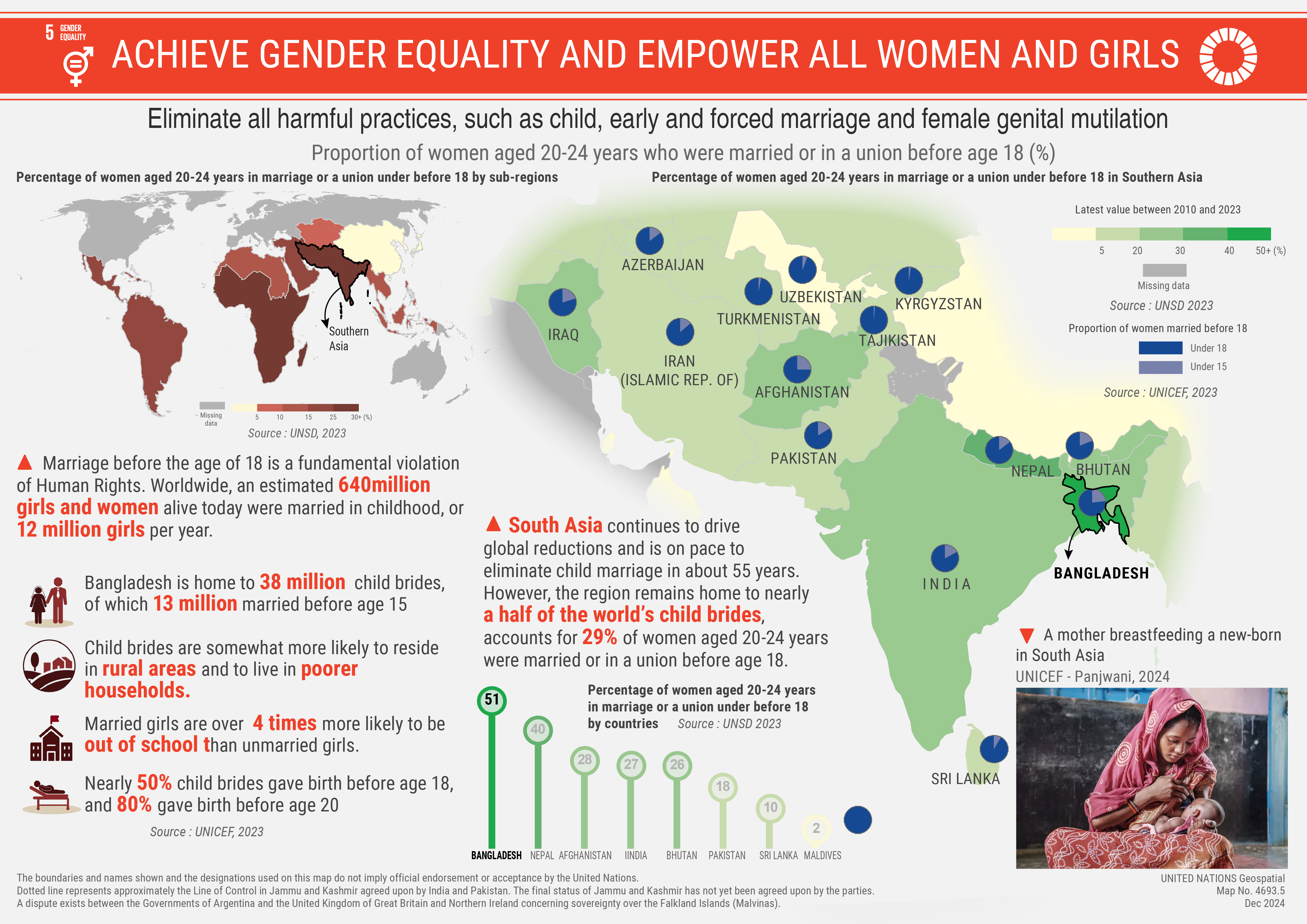 Map on SDG05 Gender Equality
 -
 Map on SDG04 Quality Education
 -
 Map on SDG03 Healthy Lives
 -
 Map on SDG 02 Zero Hunger
 -
 Map on SDG 01 No Poverty
Features
GIS Day
Starting 20 November 2024, which marks the celebration of Geospatial Information Systems day, a map on each SDG will be released until the end of 2024!
Current general map collection

Explore our current general map collection to better understand the world, general maps provide an overview of Member States and territories worldwide.
What do we do ?

Services provided to the Secretariat of the United Nations, and beyond, include geospatial visualization, data management, analysis, technology and monitoring.
Deployment of Peacekeepers

Discover our most popular cartographic products and get the latest information on deployment of peacekeepers in United Nations field operations.
Mapping for a Sustainable World
The United Nations and the International Cartographic Association published a book on best practices in cartography and how to map the Sustainable Development Goals.
Meet the UN Geospatial Network

The United Nations Geospatial Network is an inter-agency network of senior geospatial professionals within offices, specialized agencies, funds and programmes of the United Nations System.
Key documents
 Geospatial Strategy for the United Nations
Prepared by our team, the strategy aims to contribute to the data ecosystem by enabling location information for the Secretariat, in collaboration with the United Nations Geospatial Network and further with Member States.
 Blueprint Geospatial for a Better World: Transforming the Lives of People, Places and Planet
Prepared by the UN Geospatial Network, the Blueprint is the strategic inter-agency document on geospatial information that will guide the Network's future and activities through seven Transformation pathways.
 Blueprint Geospatial Landscape of the United Nations system
Compiled by the UN Geospatial Network, the Landscape is the Blueprint's companion document which includes a review of the current status of the geospatial landscape in the United Nations system.
 Integrated Geospatial Information Framework, Overarching Strategic Framework
The Integrated Geospatial Information Framework (IGIF), prepared and adopted by UN-GGIM, provides a guide for developing, integrating, strengthening and maximizing geospatial information management, and to assist countries in bridging the geospatial digital divide, secure socio-economic prosperity, and to leave no one behind.
 Global Statistical and Geospatial Framework
The Global Statistical Geospatial Framework (GSGF), prepared and adopted by UN-GGIM and the Statistical Commission, facilitates the integration of statistical and geospatial information. The framework guides and enables the production of harmonized and standardized geospatially enabled statistical data.